LAND MANAGEMENT FRAMEWORK
Modules and Features Overview
- Property & Rights Manager: accurately track properties for pre-acquisition research and post-acquisition evaluation.
- Exploration Manager: enables a detailed reporting of field activities, results, and expenditures to meet work requirements and partnership obligations.
- Jurisdiction Manager: customizes the full display of your property and tenure-related data within any jurisdiction (Canada, USA & others) to match your unique business model and terminology without additional coding.
- Calendar Manager: sets due dates and notifications for all critical events to automate compliance with obligations.
- Document Manager: acts as a centralized information storage tool for all the documentation uploaded in the system for easy access in remote locations, editing or download.
- Parties Manager: stores all entities interacting with the system, enabling the transfer of holdings between parties and their information update.
- Advanced Filter: customizes and generates reports on the fly for timely and effective decision making based on business priorities and complex queries which can be shared with your team.
- GIS Module: provides an online Map Viewer with informative displays of geospatial and mineral tenure data and valuable property characteristics using your spatial information and interfacing with government registries.
- ESRI ArcGIS Online Connector: enables a bi-directional, secure synchronization in real time between the tenures’ data and geometry in trueMINER and ESRI ArcGIS Online.
- Cloud Service: brings together your properties and exploration activities on a secure, reliable platform that guarantees streamlined online team collaboration, low costs and high ROI, efficient data management and scalability on demand to match your business needs and fluctuating market demands.
-
Configurable Dashboard
Improves awareness for decision making
-
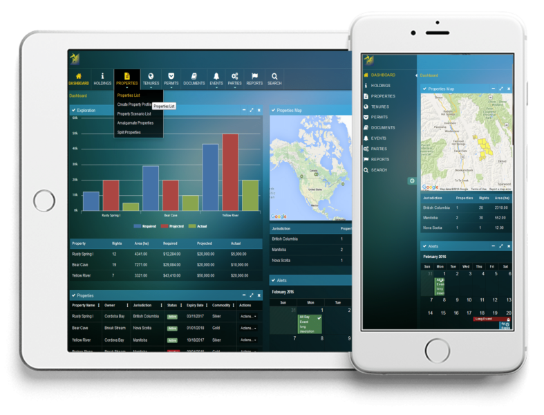
Responsive Web Design
Provides optimal viewing on any device
-
Business Process Management (BPM)
Optimizes your business processes
-
Cloud Services
Provides flexibility and scalability to a centralized data location

WHY true
trueMINER FACILITATES INFORMED DECISION MAKING ON THE FLY
The success in delivering resource management systems for both public and private sector clients has strengthened our domain and solution expertise. Using our experience in addressing through digital solutions the challenges faced by mining companies, we have designed trueMINER to help businesses in the natural resource sector streamline their internal workflows and effectively manage properties, rights, option agreements, work reporting, obligations and contracts, while ultimately focusing the field exploration work by providing dynamic information at the user’s finger tips and supporting the decision-making process.
Driven by Business Process Management (BPM) to optimize business processes, trueMINER executes targeted exploration activities organized by properties and tenures within one centralized application, removing cumbersome, costly and error-prone manual processes. The trueMINER dashboard provides dynamic updates and summaries for your entire portfolio at a quick glance, while the system is focused on streamlining your operations to help you reduce the time allocated to managing current projects and redirect resources towards acquisition and growth.
The added value of digitalizing your processes with trueMINER includes centralized data management, scalability, automation and integration to ensure that the information is always up to date and easily accessible for informed decision making.
View our brochureAs a land management software for resource-based exploration projects, trueMINER features a consistent management oversight of the property value creation, regulatory compliance, option agreement obligations, permit requirements for optimized decision making, financial commitments and stakeholder relations through informative, reliable dashboard summaries and online maps. In addition, land management operations are highly optimized through automated workflows, customization tools and the latest cloud technologies.
trueMINER’s centralized and configurable platform picks up where most software frameworks end: it provides advanced tenure life cycle monitoring and management; it delivers critical reporting; it automates notifications for financial and legal obligations to maintain tenures in good standing, and it customizes the displays to match your business needs and jurisdictional terminology.
Our property management scenarios enable comparative assessments of properties (tenure groupings) based on the interrelationship between the current geological analysis, regulatory compliance status, agreement provisions, exploration options, permitting requirements, financial arrangements and stakeholder consultations.
Well-designed dashboards can offer:
- Customized views to suit your business needs
- Role-based data visibility
- Quick access to relevant data for shared insight and understanding of business-critical information
- Ability to act on key issues in a timely and effective manner
- Improved and informed decision making
Responsive Web Design guarantees:
- Optimized mobile version for your app or website (iOS and Android, Tablet, Netbook, Kindle, BlackBerry)
- Design that responds to the user’s behaviour and environment based on screen size, platform and orientation
- Automatic adaptability to new resolutions and devices resulting in image layout flexibility and integrity
Business Process Management allows you to:
- Align the business processes with your company’s goals
- Apply IT tools to meet the challenges of your business processes
- Measure and adjust operational processes to suit business needs
- Respond quickly to project changes by adapting to new processes to seize emerging opportunities
- Maximize productivity by coordinating business demands and resources
trueMINER is a cloud-based application which does not assume any specific infrastructure dependency as it is based on a service-oriented architecture. We develop applications that operate across device platforms, especially for purpose-specific devices (e.g., portable/mobile technologies), and away from desktop-specific usability. Being in the cloud means greater adaptability to how and where your team operates.
Cloud-based applications allow for flexibility in infrastructure costs and increase business interoperability. Some of the benefits of cloud hosting translate into high ROI (Return on Investment), enhanced reliability, advanced data integrity resulting from robust security features and data encryption to reduce the risk of breaches, efficient data management, flexibility and scaling on demand, improved teamwork and increased mobility.
As we are working to expand our trueMINER cloud services, please contact us for any questions about our cloud subscription.
Cloud Service Benefits
- Scalability and adaptability to changing business needs and regulations.
- Pay-as-you-go pricing based on your unique requirements which is more cost-effective.
- Low costs and high ROI (Return on Investment) by removing the extraneous burden of investing in dedicated servers, security systems, backup and storage hardware and reducing the IT overhead for your company when it comes to configuration, implementation and maintenance.
- Increased mobility through remote work and team collaboration worldwide
- Advanced cyber security resulting from robust security features and data encryption to reduce the risk of data breaches.
- Reliability through high levels of uptime and redundancy which diminish the risk of downtown and data loss.
- Easy backup and disaster recovery options.
- Access to the latest technologies and tools, fostering innovation and growth.